Land use plan
The 1st overall update of the land use plan is currently underway
The current land use plan has been legally valid since April 2006. A municipality's land use plan is usually thoroughly revised after 10 to 15 years. This is currently the case in Radebeul. Initially, the "preliminary draft of the 1st overall update of the land use plan" was put on public display in August and September 2022. Citizens and "public interest organisations" were invited to submit their comments. 45 citizens and 25 public interest organisations responded. These comments are currently being evaluated, weighed up and incorporated into the next step. This is then no longer the "preliminary draft", but the "draft of the 1st overall update of the land use plan". This will be put on public display again so that the new land use plan for Radebeul can finally be adopted by the city council.
Why a land use plan?
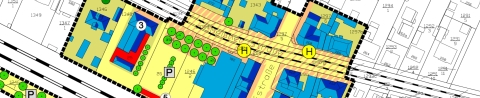
The land utilisation plan is about the big picture: in which direction should the municipality develop in the coming years? The land utilisation plan is committed to the common good and attempts to steer overall development in this direction. This is not an easy task because many different interests, both public and private, come together on the municipal territory. This is illustrated on the plan by differently coloured areas. They represent different types of use, such as residential, commercial, agricultural, etc.
It is easy for uses to interfere with each other, for example when a commercial area borders on a residential area. The issue is often how to prevent such a conflict from becoming even more acute in the future. Or it is a question of resolving it completely by relocating uses. To do this, you have to look at the entire municipal area and think long-term. At another point, it may be a question of two types of use competing for one and the same area, for example private and public interests conflicting with each other. The question then arises as to which should be prioritised. Another typical task is for the municipality to provide suitable land for important tasks, e.g. for a school extension or a sewage treatment plant. If it does not do this, it can really "obstruct" its future. Overall, the living environment of the citizens should be protected and improved. The land utilisation plan is about the long-term and large-scale development of the municipality.
How does a land use plan work?
The Building Code sets out a two-stage land use planning process. The "land utilisation plan", which is the subject of this article, is the first stage, the "development plan" the second. There is only one land utilisation plan for the entire municipal area, and the representation is correspondingly rough. By contrast, development plans can be drawn up in any number as soon as a specific planning requirement arises. Their outline is correspondingly smaller. The "binding urban land-use plans", the development plans, are developed on the basis of the "preparatory urban land-use plan", i.e. the land-use plan. They may not contradict the preparatory plan, but must go into much more detail.
One very decisive difference is that, as a preparatory plan, the land use plan, unlike the development plan, does not have any direct legal effect on citizens. Its depictions are not based on property boundaries and it is not possible to derive any claims for planning permission or possible compensation payments from them. However, the land use plan is a binding planning programme for the municipal administration and other authorities. This means that the municipality itself cannot make any decisions against its own land use plan without carrying out a parallel plan amendment procedure. The land use plan also binds the specialised authorities, provided they have not raised any objections during the participation procedure.
What is the procedure?
The Building Code specifies exactly how an update is to be carried out. This takes place in a three-step process that can be repeated several times. The city administration starts by preparing a preliminary draft that contains the necessary and desirable changes to the previous land use plan from a technical point of view. In the next step, the city council's urban development committee in particular adopts the perspective of local politics and discusses the preliminary draft with the city administration. Finally, the result is presented to the public: this phase, known as "early public participation", was carried out in August and September 2022.
After the early public participation phase, it's back to the city administration, which writes a recommendation for each public comment on how it should be handled from a technical perspective. However, it is always the municipal committees that decide what is ultimately included in the plan. In this way, the actual draft for the new land use plan is created from the preliminary draft. This draft is then "put on public display" and another opportunity is given for comments. If this leads to further changes to the draft, these are discussed again in the urban development committee and the plan is then put out to public consultation again.
Once this process has been completed, the land use plan can be adopted by the city council. It must then be examined and approved by the higher administrative authority and finally publicised. It is important that the "public interest bodies", such as specialised authorities, are also involved in the entire process alongside the citizens. Their comments and suggestions are also of great importance.
Landscape plan
The landscape plan is the starting point for all utilisation considerations and forms the basis of the land use plan. Landscape planning provides benchmarks for assessing the environmental impact and environmental compatibility of planning measures and considers the totality of natural resources and indicates the limits of human utilisation. The most important statements in the landscape plan are incorporated into the land utilisation plan where appropriate.
The landscape plan is based on the nature conservation requirements of the legislator (in particular the Nature Conservation Act) and the laws of regional planning and spatial planning. In particular, the landscape plan is intended to safeguard the protected assets of soil, water, air, animal and plant species and the landscape of the town of Radebeul.
Radebeul has an extraordinary topographical and natural diversity with near-natural forests, the Elbe valley and the Lößnitz slopes, which should be preserved for the future.
In the long term, earlier undesirable developments such as the urban sprawl of Radebeul's recreational areas should be carefully reversed. This process cannot begin immediately and is to be understood as a declaration of intent for future developments. However, the landscape plan also identifies measures that are to be implemented in the short term. These include measures for the creation and expansion of green links and the creation of retention areas for the natural infiltration of water.
Radebeul has developed a unique cultural landscape with woodlands, vineyards, open spaces and parks as well as orchards and other agricultural and horticultural uses, which should be preserved for present and future generations.